3D Earthworks Modelling: The Ely Project
Updated: Oct 8
A 3D earthworks model makes proposed levels easier to understand. Bringing the survey and design together helps estimating and site teams review roads, plots, ponds and the connections between them.
Ely: from site overview to model detail
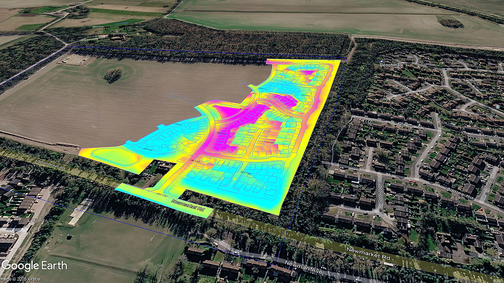
For this residential development in Ely, Cambridgeshire, I produced an AGTEK earthworks model and categorised volumes into plots, roads, ponds and key development areas. The exercise reviewed around 50,000 m³ of fill.

The aerial view helps you place the development in its surroundings. You can follow the road layout, see how the plots are grouped and locate the ponds around the site. The underlying survey and design files provide the measurement basis; the aerial image provides context.

The oblique model view makes the changes in level and the shape of the roads, plots and surrounding slopes easier to inspect. The colours are part of the original model display; use the relevant drawing legend and quantity schedule when interpreting levels or cut-and-fill depths.
Questions the model helps a team ask
How do the proposed roads and plots meet at their boundaries?
Where do steep changes in level or retaining features need closer review?
Which work areas account for the cut and fill, and what changes when a design is revised?
The checks behind the picture
Before reporting quantities, confirm the survey date, design revisions, coordinate system, vertical datum and units. Review surface boundaries, breaklines and gaps, then agree the formation levels and allowances to be measured.
For example, a finished road surface and a road formation surface represent different levels. The quantity report needs to say which surface was used and how stripping or build-ups were treated. Record the input versions so later revisions can be compared with the same baseline.
What should come with a model?
A quantity schedule split into agreed plots, roads or work areas.
Review drawings and the agreed model or surface files.
A record of input revisions, measured surfaces, units, assumptions and exclusions.
A tender model supports measurement and comparison. Machine-control preparation also requires the agreed design, equipment formats and site workflow. We confirm the intended use and responsibilities for design approval and site setup at the outset.
Discuss a modelling package
Send your existing survey, current design drawings, required outputs and deadline. Tell me whether you need tender quantities, a design comparison or machine-control preparation, and we can agree the package.
Comments